Tropical Storm Ernesto gained strength on Tuesday morning as it headed toward the Virgin Islands and Puerto Rico, where forecasters said it could bring powerful winds and heavy rain — up to 10 inches in some places — before potentially intensifying into a hurricane.
Ernesto became the fifth named storm of the 2024 Atlantic hurricane season when it formed Monday along a fast-moving path to the Caribbean. The storm comes on the heels of Hurricane Debby, which lashed parts of the southeastern United States last week with disastrous flooding and brewed up a flash of severe weather that ultimately touched much of the East Coast. Ernesto wasn’t expected to strike the mainland U.S., the National Hurricane Center said.
NOAA/National Hurricane Center
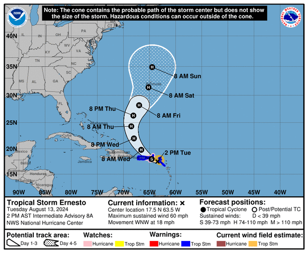
Maps charting Ernesto’s path, according to the latest forecasts Tuesday afternoon, suggested the storm would continue on its route toward the U.S. and British Virgin Islands and Puerto Rico, after traveling across portions of the Leeward Islands. Ernesto could either reach or pass over the Virgin Islands and Puerto Rico by the evening, although forecasters said it was possible the system’s track would carry it near the islands instead of over them.
Ernesto could develop into a hurricane after leaving the Virgin Islands and Puerto Rico, which would require its maximum sustained wind speeds to meet or exceed 74 miles per hour. That could happen by Wednesday, forecasters said, although an initial timeline for Ernesto’s strengthening suggested it wouldn’t reach the threshold necessary to warrant hurricane status until early Thursday.
NOAA/National Hurricane Center
As of 2 p.m. ET on Tuesday, the storm was churning in the Atlantic Ocean, about 85 miles east of St. Croix and about 175 miles east-southeast of San Juan, Puerto Rico, according to the hurricane center. It was traveling west-northwestward at 18 mph and packing maximum sustained winds of 60 mph.
Hurricane watches were in effect for the U.S. Virgin Islands, Culebra, Vieques and the British Virgin Islands. Tropical storm warnings were also in effect for those places, as well as in Puerto Rico, St. Kitts and Nevis, Montserrat, and Anguilla, St. Martin and St. Barthelemy and Sint Maarten. Previous tropical storm warnings for Antigua, Barbuda and Guadeloupe were discontinued Tuesday afternoon.
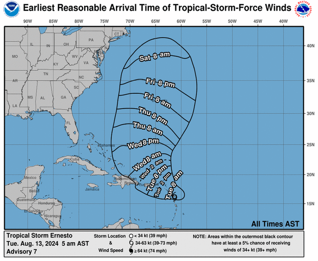
Hurricane watches are issued when hurricane conditions are possible in a given area within 12 hours or so. Tropical storm warnings are issued when forecasters expect tropical storm conditions to impact an area within 36 hours, but meteorologists said at 2 p.m. ET on Tuesday that tropical storm conditions were expected to begin in the Virgin Islands and Puerto Rico by nighttime, and potentially even sooner than that. Powerful winds and other weather conditions typical of a tropical storm were already happening in the Leeward Islands, they said.
Tropical-storm-force winds extended outward up to 105 miles from Ernesto’s center on Tuesday afternoon — a sizable expansion from its 70-mile reach in the morning — according to the hurricane center.
Not unlike Debby, which dumped devastating and, in some instances, historic rainfall on southeastern U.S. states last week, Ernesto’s primary threat was inundation, although slightly less rain was forecast for this week compared with last week’s hurricane.
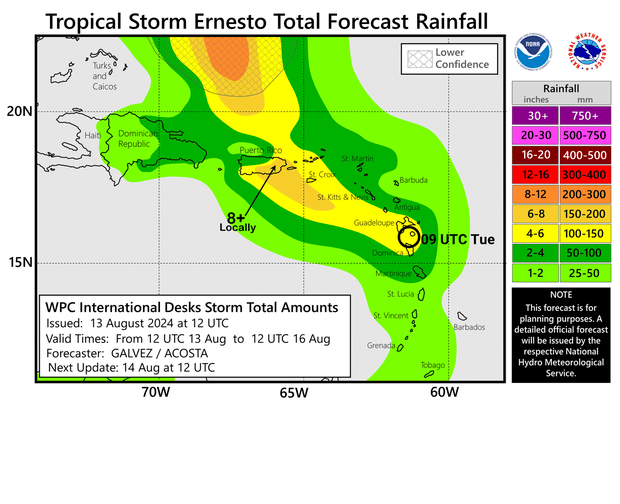
Ernesto was expected to shower parts of the Leeward Islands and Virgin Islands with 4 to 6 inches of rain, while southeastern Puerto Rico was expected to see 6 to 8 inches, although forecasters warned that as much as 10 inches of rain could fall in certain places.
CBS News senior weather producer David Parkinson said Tuesday morning that even a foot of rainfall could be possible in areas where the terrain might lend itself to that. Northwestern Puerto Rico was forecast to get less rain, between 2 and 4 inches in total.
NOAA/National Hurricane Center
“Heavy rainfall may result in locally considerable flash flooding and mudslides in areas of the Leeward Islands through today, and over the Virgin Islands into Puerto Rico by later today through Wednesday,” the hurricane center said in an advisory Tuesday morning.
Ernesto was also expected to fuel storm surge, between 1 and 3 feet above ground levels, along the eastern coast of Puerto Rico from San Juan, the capital city, to Guayama, and to the islands of Culebra and Vieques. The same peak surge forecast could materialize in the U.S. Virgin Islands, including St. Thomas, St. John and St. Croix, and in the British Virgin Islands. The hurricane center warned that surge would be accompanied by large, destructive waves in coastal regions.
NOAA/National Hurricane Center
By Thursday morning, when Ernesto was forecast to have grown from a tropical storm to at least a Category 1 hurricane, it would likely continue tracking northward over the western Atlantic on a path toward Bermuda, where it could make landfall on Sunday, Parkinson said. He noted that the eastern seaboard of the mainland U.S. could see rip currents and larger waves than usual as an indirect consequence of the storm.
“It is too soon to know what impacts Ernesto could bring to Bermuda late this week,” the hurricane center said Tuesday, adding that “interests there should monitor the progress of this system.”


