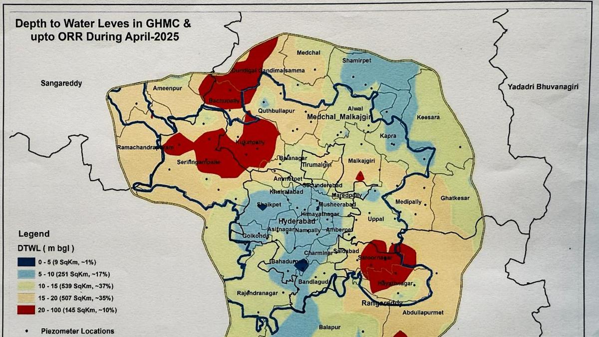
The areas where the water table has fallen below the 20 meter mark includes Serilingampally, Hayatnagar, Abdullapurmet, Saroornagar, Kukatpally, Bachupally, Malkajgiri and Dundigal mandals
| Photo Credit: BY ARRANGEMENT
HYDERABAD
The groundwater table in 145 square kilometres within the Outer Ring Road area has fallen below the bellwether mark of 20 metres below the ground level, according to the Telangana Ground Water Department data.
“While the annual and decadal water table has risen over the past few years in Telangana, over-exploitation has become the norm in western and southern parts of Hyderabad. Turning it into the dangerous red zone in the period up to April 2025,” informed K. Laxma, director of Telangana Ground Water Department.
What is a red zone?
An area falls under a red zone when water level drops below the 20 metre mark
The areas where the water table has fallen below the 20 meter mark includes Serilingampally, Hayatnagar, Abdullapurmet, Saroornagar, Kukatpally, Bachupally, Malkajgiri and Dundigal mandals. The most precipitous drop can be seen in the graphic.
Area under red zone despite receiving 19% excess rainfall
The rise in area marked as red zone is despite the fact that the area under consideration received 19% excess rainfall (937mm) over the long-term average of 786 mm. Incidentally, the decadal annual average ground water levels within the Outer Ring Road area has shown a rise of 2.34 metre.
46 mandals within GHMC over-exploited the groundwater basin
Earlier, in 2024, 11 out of 46 mandals within the Greater Hyderabad Municipal Corporation, mostly in central and southern parts of the city, had over-exploited the groundwater basin. Amberpet, Ameerpet, Asifnagar, Charminar, Golconda, Himayatnagar, Khairatabad, Musheerabad, Saidabad, Secunderabad and Shaikpet mandals have overdrawn ground water with Charminar tapping 177% of the available resource.
Human activity changed water table
“The change in water table is mostly due to anthropogenic (human activity) reasons. Encroachment of tanks, lakes and other water bodies and plotting are the major reasons. There used to be a big lake near Shivam near DD Colony. Now only houses can be seen there. Downstream of the lake used to be another small water body that too has disappeared. At the same time, we are seeing the rise of tall towers where water usage is above the 150 litre mark for urban users,” says Mr. Laxma.
Published – May 13, 2025 01:55 pm IST


