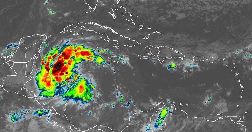
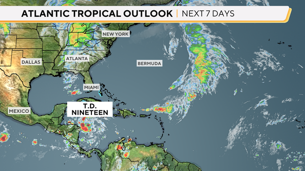
Tropical Storm Sara formed in the Caribbean on Thursday, becoming the 18th named storm of the 2024 Atlantic Hurricane Season. The system, previously called Tropical Depression 19, developed in the western Caribbean earlier this week and intensified while traveling westward on a path toward Central America.
Sara has sustained winds of 40 mph and is located around 205 miles east-southeast of Isla Guanaja, Honduras, moving west, the National Hurricane Center said. A weather system is considered a tropical storm when its wind speeds accelerate to at least 39 mph.
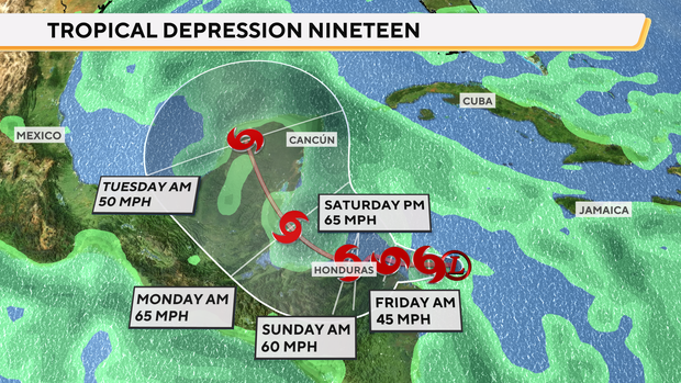
The storm is expected to linger in the Caribbean through the weekend and slowly move into the Gulf of Mexico early next week, CBS News meteorologist Nikki Nolan said. After that, the weather system could potentially make its way toward Florida.
CBS News
“Long-range models continue to forecast it tracking back towards Florida by the end of next week, but a lot can change between now and then,” Nolan said Thursday morning. “Florida residents should closely monitor the forecast updates as they come in.”
The Atlantic Hurricane Season officially runs from June 1 until Nov. 30, with activity typically peaking between mid-August and mid-October. An average season brings 14 named storms, seven hurricanes, and three major hurricanes, according to the National Oceanic and Atmospheric Administration, which did predict the 2024 season would produce “above average” numbers.
What is the projected path of Tropical Storm Sara?
Tropical Storm Sara could potentially bring catastrophic rainfall to parts of Central America. Between 10 and 20 inches of heavy rainfall are possible in Honduras early next week, forecasters warned, with up to 30 inches accumulating in some places.
CBS News
Forecasters at the Miami-based National Hurricane Center said they expected “life-threatening” flash floods to hit northern Honduras and persist through the weekend. The hurricane center also warned of potentially disastrous mudslides caused by the storm, especially in the mountainous area along and near Sierra La Esperanza on the country’s northeastern coast. They estimated those conditions would persist through the weekend.
The rest of Honduras, Belize, El Salvador, eastern Guatemala and western Nicaragua will likely receive between 5 and 10 inches of rainfall as the storm runs its course through that region, but up to 15 inches are possible.
Governments across Central America have issued various watches and warnings as people brace for Sara’s effects. Vast sections of Nicaragua and Honduras, including the Bay Islands, are under either a hurricane watch or a tropical storm warning, according to the hurricane center.
Will Tropical Storm Sara become a hurricane?
It remains to be seen whether Sara will grow into a hurricane by the time it’s expected to move close to the eastern coast of Honduras on Friday or Saturday, but forecasters said the storm would likely “be near or at hurricane strength” when that happens.
A tropical storm becomes a hurricane when its sustained winds reach at least 74 mph, making it a Category 1 on the Saffir-Simpson Hurricane Wind Scale.
Forecasters also cautioned residents of Belize and Mexico’s Yucatan Peninsula to be ready for possible impacts of Sara early next week.
Will Tropical Storm Sara hit Florida?
After entering the Gulf of Mexico, the consensus of the forecast models has the storm making a right-hand turn and heading toward Florida by late next week, though Nolan noted that conditions can quickly change.
Hurricane hunters were flying into the area Thursday to investigate the strength and structure of the developing weather system.
Forecast models take in the current environmental factors along with historical data to compute “spaghetti plots” of where systems may track. Each model uses different computations, and the forecast track is an output of the consensus from those models.
CBS News
“It is too soon to determine what impacts the system could bring to portions of the eastern Gulf of Mexico, including Florida, the Florida Keys, and Cuba during the middle portion of next week,” the hurricane center said Thursday. “Residents in these areas should regularly monitor updates to the forecast.”
contributed to this report.


